Saturday, September 18, 2010

Columbine Lake, 12,685', and Peak 13,300', Via Slidepath Route

Essence: Off-trail, tundra-infused route to Columbine Lake, a new definition of blue. Then, a moderate climb to Peak 13,300' to gaze upon sapphire and indigo waters, window to another world.
Travel: From Durango, drive north on US 550 about 47 miles to Silverton. Continue north on the San Juan Skyway 7.5 miles to the "Chattanooga Curve", the right-turning hairpin at the southern base of Red Mountain Pass. At the bend's apex, turn left and drive up the 4WD, historic mining road about 1 mile and park in the pull-out at 11,160'. Starting from US 550 adds 2 miles roundtrip and 700 feet of gain.
Distance and Elevation Gain: 7 miles, 2,500 feet of climbing
Time: 5:30 to 7:00
Difficulty: Off-trail; navigation considerable; mild exposure on Peak 13,300' summit block
Maps: Silverton, Ironton, Telluride, Ophir, Colo. 7.5 Quads
Date Hiked: September 18, 2010
Quote: As we readily follow an agreeable object that flies from us, so we love to contemplate blue, not because it advances to us, but because it draws us after it. Goethe, Theory of Colors.

Columbine Lake on a crystalline autumn day.

Note to Hikers: There are three routes to Columbine Lake. What follows is a description of the Slidepath Route. I highly recommend it for the navigation savvy. If you wish to take a trail all the way to the lake, please see my post, Columbine Lake Via Standard Trail. The trail begins off the Ophir Pass Road, ascends 2,550 feet to the lake and is 6.6 miles roundtrip. Another option is a cross-country route from Porphyry Basin.

Map: The Slidepath Route to Columbine Lake is the Red-Line Route. The broken red line is an option for the return. Upon reaching the lake, join the standard Black-Line Route to climb Peak 13,300'.

Slidepath Route: The first half mile is the hardest. From the parking pull-out, walk north a few paces to a branch of Mill Creek and ascend about 100 feet. Then, turn left/west into the largest avalanche slidepath in North America. Climb 1,200 feet up the very steep, grassy pitch. Abruptly, the terrain levels considerably. This image was shot near the top of the climb in August, 2017.

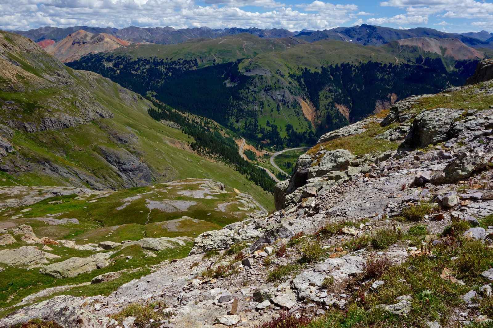
Turn left/south as these hikers have done. Point 13,228', the blunt end of a southeast trending ridge, is shown.

Landforms will guide your ambling way across tundra punctured by volcanic boulders. Contour two miles to the southwest staying between 12,600 and 12,800 feet. Approaching the lake, Pt. 13,614' (below, right) and Lookout Peak, 13,661 feet (left of center) frame the route. (THW, photo)

Pass between two diminutive ponds and then the east shore of Lake 12,758'.  Presently, cerulean Columbine Lake snatches your breath away. Peak 13,300' rises above the lake, image-left.

Colors are the deeds and sufferings of light. Goethe

In 1810, Goethe wrote that absolute knowledge was not vital for joy or even contentment.  The highest goal that man can achieve is amazement. For most, spending the day at the lake is astonishing enough. However, your worldview will be altered indelibly if you just walk two miles roundtrip further and climb 650 additional feet to Peak 13,300'. It is simply done. Looking at the image below, the route starts on a low bench on the right/west side of the lake and curves up the grassy/scree slope to a thin saddle at 13,100 feet.

These hikers are closing in on the saddle. (THW, photo)

From the saddle, climb 120 feet up a scrabbly west-facing ridge. Continue east to the base of the summit block, shown.

There are three routes to the crest, climber's choice. The east approach is Class 2+ with some exposure and loose rock, typical of San Juan volcanics, image-right. The west wall is a more protected Class 3 scramble, image-left. Or, scale the challenging Class 3 center crack.

 From the summit look through a cobalt window into another world. (THW, photo)

Allow your eye to travel along the west ridge to the highpoint, Lookout Peak. The image below was taken from Lookout shooting back at Peak 13,300', shown directly above the climber. The lake is a muted azure on a snowy day in October. Stay with this image and look at the gentle extension to the right/south of Peak 13,300'. Be sure to walk to the end of this tabletop before returning to the lake.

Those feeling playful can descend on the beguiling rib of stone that swirls from Peak 13,300' down to the lake. Lookout Peak is just left of image-center at skyline.


Color is the first principle of Place. Ellen Meloy

If we are to hunger, let it be a hunger of the senses, not material desire. Let it be a surrender to the instinctive pull of remoteness and the intimacy of beauty. Ellen Meloy

When you can, or must, tear yourself away from turquoise waters, return the way you came.
 

Saturday, March 13, 2010

Southeast Utah: Whirlwind Draw, Moqui Canyon, Steer Gulch

Utah exploration was truncated from five days to three, framed by winter weather. I left town on 35 mph icy roads and returned on snow-pack at the same speed.  While I regret coming home early, I don't lament the deceleration process this trip enforced.  Especially after reading, In Praise of Slowness: Challenging the Cult of Speed, by Carl Honore. My life is "velocitized".  I spent days researching and pondering a spring break location.  The challenge: stay close and do not camp in the snow.  I decided on two canyons that flow into the San Juan River under 5,000 feet on Grand Flat, and Moqui Canyon that drains into the Colorado River, their confluence under the waters of Lake Powell.

I stopped by Natural Bridges National Monument to see if I could get down into White Canyon and explore Deer, one of my "projects".  As you can see from this photo taken on Hwy 95 fairly close to the monument, it looked promising. Many of you will recognize the dome on Comb Ridge and snow covered Abajo Mountains.  Further up the Grand Gulch Plateau, snow accumulated fast.  It was two feet deep in the campground and no one had plowed the road or shoveled off the picnic tables.  Inside the visitor center I found three brand new, kindly but befuddled rangers who said the trails weren't open and even they hadn't visited the three bridges, ever.  The table turned as they drilled me for information about their park.  That was wild.

Given conditions, this trip was about getting into canyons I could access.  A major storm system that cleared out the previous night turned roads to clay.  I took my chances on Whirlwind Draw, a little known, shallow canyon overshadowed by heavily visited and spectacular Grand Gulch to its east.  In 1986, naturalist Ann Zwingler wrote beguilingly of the modest Whirlwind in her book, Wind in the Rock.  I've been enticed ever since.

I wish I could sit here for eons and watch as these sandstone wall crumble, grain by grain, and fall to the floor of this dry wash, become rearranged by water and wind, compressed to other cliffs, excavated into other canyons, and feel the wind all the same. The rock changes, the channel changes, the wind just carries air from one place to another, more constant than the rock. The rock is ephemeral, the wind eternal. Ann Zwingler

I headed down Hwy 276 towards Halls Crossing, then hung a left on the dirt road towards Clay Hills Crossing, the take-out for the San Juan River, and onto a tiny two track for half a mile until I wimped out and parked.  I punched it through some muddy puddles and slipped around in the clay. Admittedly, it was slimy mud walking but I reveled in the clear blue silence, the views of Navajo Mountain and Monitor Butte, and the challenge of route finding around a pour-off when the canyon got a little deeper.

This is as deep as Whirlwind gets and I'm on top only because I couldn't quite make one climbing move by myself.  Eventually I got back down in, and walked until I was transformed and restored. Because of a late start I only walked seven miles total, coming within a mile or so of the San Juan River. Reportedly there are barrier falls that prohibit access to the river but I'll return to give it a try. I camped that night in utter simplicity, sleeping in my truck against the cold, parked on a little slab of sandstone.

Seeking greater warmth, the second day I drove down Hwy 276 and then out Burnt Spring Road six rugged 4WD miles to an arm of Moqui Canyon.

After slidding a mile down a humongous sand dune, I dropped onto the canyon floor.  While a grader had created switchbacks down the dune, people had clearly gotten stuck on several corners. Just downstream I explored a south facing alcove seen from the top and found six elaborate petroglyph panels. This image depicts a gorgeous example of Glen Canyon Style 5, art of hunters and gatherers. Note the 20 vertical lines in the big horn sheep. I spent the rest of the day walking up canyon, knowing I'll eventually access the lower portion down to the Colorado River, now inundated by Lake Powell.

I spent a second night deeply asleep in profound silence and solitude.

Early morning I drove a few miles south to Halls Crossing on Lake Powell and took this picture of Fifty Mile Ridge (west of Hole in the Rock Road) on the fly.  I could have stopped in the middle of the road because the only other vehicle was the Park Ranger's. He waved with such enthusiasm I felt like a first spring flower. Remarkably, no one was in the campground and the little store where I hoped to get ice was closed for the season.

Delighting in the solitude of the obscure, I returned to Grand Flat and explored Steer Gulch. The shallow wash didn't disappoint; it was comprised of fluted swirling pink and white sandstone.

Again, I simply drove out a tiny two track that's not even on my map and choose a side canyon that looked like it would yield access into the main. The canyon had flashed a few days earlier rising four feet into a torrent. The rain turned little nothing rivulets into substantial somethings for their 15 minutes of flash. I quickly learned how to judge the suction quotient of the slimiest mud, lucky to have walked out with two boots. I was richly rewarded for the mud slog by this petroglyph panel of three feet in San Juan Basketmaker Style walking up a wall going somewhere important.  Note that the top and bottom have 6 toes!

By the time I got out of the gulch storm clouds were billowing.  Needing to get down low, I drove to Sand Island Campground just west of Bluff at 4,000 feet.  It was deserted except for a group of college students from Chicago who were putting on the river.  I felt for them as my truck rocked me to sleep in a gale so stiff I was worried about toppling cottonwoods.  Dreams of hiking for two more days were dashed when I woke to this scene. Sure, I could have hiked in the cold but I only live two hours from Bluff so I headed home, planning to return in April.

I took a back road along Mc Elmo Creek that spills into the San Juan River.  This compact river valley is home to an old Colorado ranching community.  I was lucky to get this photo by stopping in the middle of the road and leaning out the passenger window.  No one else was driving on the three inches of snow and slush. There's a swing set to the right of the home and an ancient tractor under the eve.

In Deseret News, 1861, a reporter described southeastern Utah as, "measurably valueless, excepting for nomadic purposes, hunting grounds for Indians, and to hold the world together."

An important note from author Steve Allen about protecting endangered National Monuments in Southern Utah.